What it does
LUNAS provides direct measurement of relative sea-level change. Using a GNSS antenna, it simultaneously tracks sea level via signal reflection (GNSS-IR) and land subsidence via precise positioning. This integration delivers the true flood risk to a community.
Your inspiration
As engineers in the Philippines, we see a terrifying reality: our land is sinking while the sea is rising. In some areas, subsidence reaches 12 cm/year, making floods far worse than sea-level data alone suggests. Yet communities fight this two-front battle blindfolded. Expensive tide gauges and rare subsidence surveys measure these threats in isolation. There is no unified system to show the true, relative sea-level change. This data gap leaves millions vulnerable. LUNAS was born from our urgent need to create a single, affordable tool to see the full picture and empower communities to adapt.
How it works
LUNAS uses a single, solar-powered station with a low-cost Global Navigation Satellite System (GNSS) antenna performing two geodetic measurements at once. (1) Sea Level via GNSS Reflectometry: An antenna pointed towards the sky captures satellite signals reflected off the water. Analyzing the interference pattern between direct and reflected signals calculates the precise distance to the water surface, creating a tidal record. Our field tests proved this achieves a stunning RMSE of just 4.18 cm compared to official tide gauges. (2) Land Subsidence via Precise Positioning: The same antenna tracks its absolute 3D position with millimeter-level precision. Consistent downward movement detected over time reveals the rate of land subsidence. By integrating these two datasets, LUNAS provides a direct measurement of relative sea-level change.
Design process
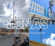
Our journey was one of integration and iterative problem-solving. We started by testing if existing government GNSS stations could be repurposed. After assessing eight sites, we found them unsuitable; obstructions blocked reflected signals and their setup wasn't designed for high-precision vertical monitoring. This failure was pivotal, proving a purpose-built, dual-function system was the only path forward. We designed a customized, self-sufficient field station, engineering a single, weatherproof, solar-powered unit to house a GNSS receiver, a mini-computer, and a power system that could run autonomously for weeks in tropical conditions. A campus trial run let us debug power management and data processing workflows. We then deployed the LUNAS prototype in Limay, Bataan, for a two-week test beside an official tide gauge. The system ran flawlessly, collecting two parallel, high-quality datasets. This successful test provided crucial data to refine our design. We optimized power usage to determine exact solar panel needs for long-term autonomy. We fabricated a robust, weatherproof housing with an integrated steel frame for durability and developed a more efficient data transmission system for remote downloads, a critical step towards a scalable, low-maintenance network.
How it is different
LUNAS creates an entirely new category of environmental monitoring. It is not merely a cheaper tide gauge or a simpler GNSS station; it is the first low-cost system to integrate both functions, solving a problem that currently requires two separate, expensive, and logistically complex deployments. While traditional methods measure sea level or land movement in isolation, LUNAS measures their combined, real-world impact. This provides a direct, continuous measurement of relative sea-level rise—the single most important metric for coastal planning, which is currently unavailable as a continuous data stream in the Philippines. It replaces a fragmented, cost-prohibitive approach with an elegant, affordable, and scalable solution, democratizing access to data essential for predicting flood risk, informing land-use policy, and saving lives.
Future plans
Our prototype lays the foundation for a nationwide geodetic network. We envision LUNAS as the backbone of climate adaptation in the Philippines and a model for other vulnerable nations. We hope to launch a national network by deploying 10 LUNAS stations in high-risk areas within two years. These will stream data to a cloud platform for automated, hyper-local flood forecasts that consider both sea level and land subsidence. LUNAS will also drive policy by providing clear evidence for groundwater management and resilient coastal zoning. Future upgrades will include sensors for soil moisture and wave height.
Awards
Our project was recognized as the Best Undergraduate Thesis from the Department of Geodetic Engineering, UP Diliman. It won the Dr. Francis Chua Innovation Awards with 1st Place in Design and a Research Finalist spot, and emerged as 1st Runner-Up at the prestigious 2025 Engineering Innovations Congress.
Created by
Team members
- Leila Micahella Cruz
- John Michael Rey Zamora
- Jasper Molleno
- Alexi Mae Narca
- John Dave Maclang
- Dave Liam Ngo
- Luis Carlos Mabaquiao
University / Institution
- University of the Philippines - Diliman
Region
- Philippines


Share this page on